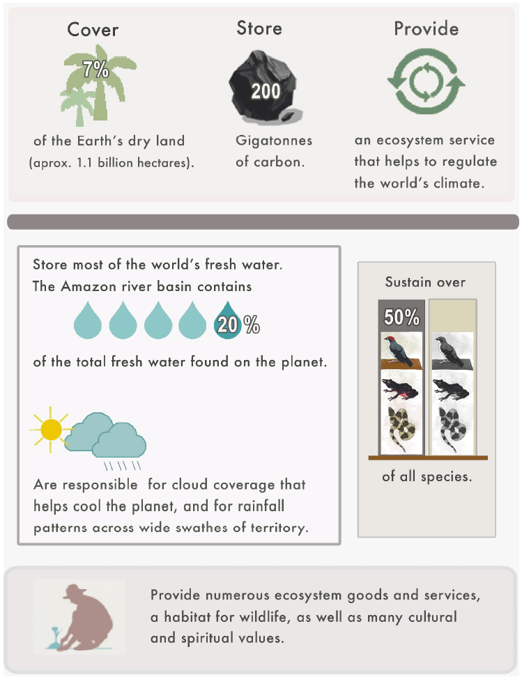
Tropical forests store hundreds of billions of tons of carbon. A significant influence on the Earth’s climate, they provide a buffer against flood and drought, stabilize soils, influence rainfall patterns, and are home to wildlife and indigenous people.
Despite their importance, human activity such as conversion of forest land for monoculture and livestock production and logging is causing the loss of some 5.4 million hectares of tropical forest per year, an area equivalent to roughly 1.8 times the size of Belgium.
Keenly aware of the impact of deforestation and forest degradation to the overall health of their economies and communities, and recognizing the importance of forests in the context of climate change, forested countries are developing policies aimed at improving forest management practices, as a major solution in climate change mitigation and adaptation.
To this end, a key first step is to develop and implement national forest inventory systems (NFIs), which accurately measure biomass and timber stocks to monitor carbon dioxide emissions, and removals from forest cover and structure change.
Developing better baseline data is key to supporting forest-related climate policies that are specific to each country or region. In this context, conducting national forest inventories (NFIs) is of the utmost importance.
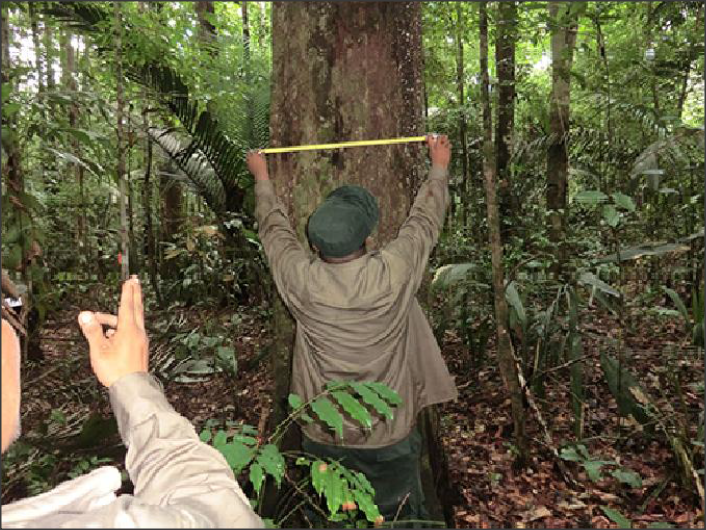
Measurements of biomass and timber stocks, undertaken in any NFI enable carbon dioxide emissions monitoring and forest cover removal monitoring, as well as changes in forest structure resulting from forest management.
As a basis for its international cooperation programmes, ANRICA believes that each country must engage in NFIs that are realistic, and that closely match both their needs and their potential capacity. Moreover, NFIs must be locally driven, building national and local capacity, and fostering scientific thinking among practitioners.
Possessing centuries-old expertise in managing forests, both locally and abroad, ANRICA experts engage with partners directly, considering local realities, restrictions, experience and opportunities to provide custom-designed technology transfer, training and capacity building for all necessary stages needed to build a NFI system.
As part of climate change mitigation efforts, tropical forest countries are especially encouraged by initiatives such as the 2011 Reducing Emissions from Deforestation and Forest Degradation (REDD+) program, and others of its kind. Centred on reducing forest carbon emissions by decreasing deforestation rates, while expanding forest area (e.g. forest plantations), these programs promote carbon dioxide removal from the atmosphere, by increasing forest coverage, while simultaneously achieving economic development.
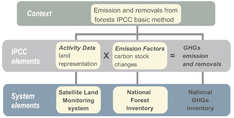
Emissions = Activity data * Emission Factor
“Activity data” defined as the spatial changes in forest area over time (i.e. forest loss and gain), best tracked through satellite imagery; and
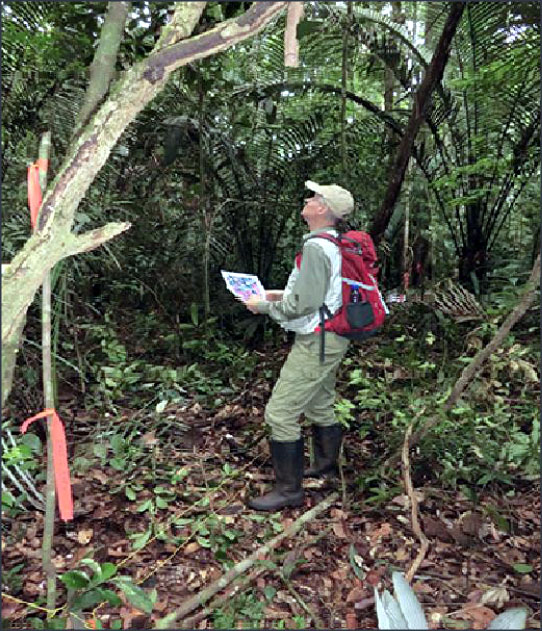
Emission factors representing the changes in carbon stocks contained in above-and below ground biomass, litter and soils. Acquired by means of labour-intensive and onerous fieldwork (i.e. ground verification by statistical sampling), various parameters such as above-ground biomass, vegetation height, stand density and structure, species distribution, and carbon content in litter and soils are used in green-house gas inventories as input data for estimation of carbon uptake and loss.
International standards in statistical precision. Certain targets require a minimum number of ground sampling plots, which in turn results in decreased costs for labour-intensive ground trothing.
A long history of sustainable forest management and decades of developing forest resources monitoring methods in Austria – i.e biomass measurements – are testimony to ANRICA’s expertise in combining forest green-house gas monitoring with national forest inventories.
Together, tropical forest specialists in Suriname and ANRICA developed a cutting edge, and low-cost system suited to national forest inventories, and reliable green-house gas monitoring in tropical forests. This system is based on high quality and reliable data collection and monitoring of Carbon emissions.
It is also compatible with reporting and verification requirements of the Intergovernmental Panel on Climate Change (IPCC), and REDD+ monitoring goals, both central to climate change mitigation and adaptation planning today.
This new NFI combines state-of-the-art remote sensing using largescale aerial photography, with ground verification data collected in the field. Based on these data, sophisticated forest biomass and timber stocks models are developed, applying sound and intelligent statistical methodology.
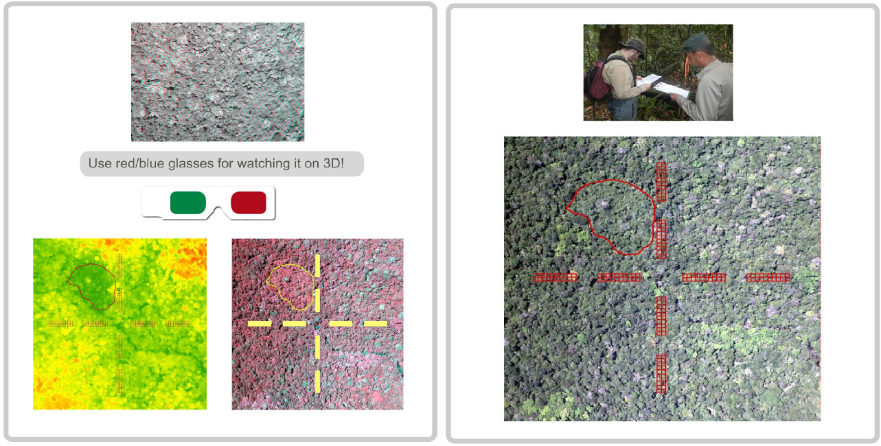
Systematically sampled biomass characteristics retrieved from aerial images, supported by ground truthing, are the core principle of our system.
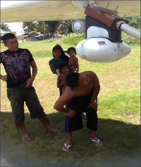
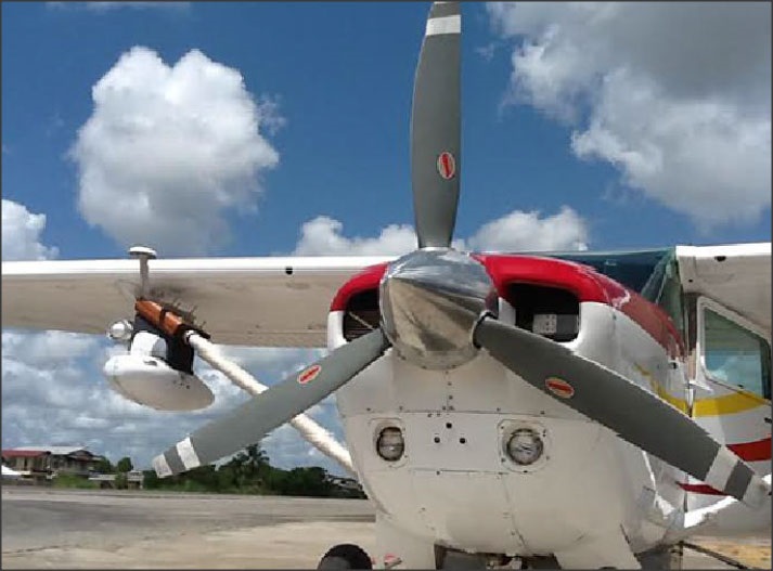
Data from high density 3-D geo-referenced aerial images – combining RGB, infrared and LIDAR technology – is recorded by a remote sensing platform (ADAM C), mounted on a standard high-wing, single-piston engine aircraft (i.e. Cessna 162 – 206) – neither requiring specifically adapted planes, nor ground control points for geo-referencing. The system employs a two-phase statistical sampling approach combining systematic aerial sampling methods with ground verification on a permanent sample plot grid.
50% cost reduction at +/- 5% uncertainty
In this approach, mathematical modelling allows for the estimation of target parameters such as biomass and timber stocks, in addition to their associated statistical uncertainty by achieving a 95% confidenceinterval.
This means an uncertainty of ± 5.0% or smaller for key parameters such as biomass and timber stocks which is a commonly accepted good NFI standard.
The two-phase forest assessment system developed by ANRICA and its partners, results in data acquisition costs that are approximately 50% lower than conventional terrestrial inventories. Cost efficiencies occur because aerial sampling is comparably cheaper than wall-to-wall imaging. In addition the number of highly expensive ground plots can be substantially reduced, particularly in countries where access to the forest is difficult.
Most importantly, the system generates data for many different purposes with a single set of inventory plots established throughout the country.
Forests play an important role in climate change. They contribute about one-sixth of global carbon emissions when cleared, overused or degraded. They react sensitively to a changing climate. When managed sustainably, they produce wood fuels as a benign alternative to fossil fuels. And they also have the potential to absorb about one-tenth of global carbon emissions projected for the first half of this century.
By 2020 all countries will be required to operate reliable and robust national Green-house Gas Monitoring Reporting and Verification (GHG-MRV) systems that also include the land use sector. Adequate information about forests and forest carbon pools and changes in terms of quantity and quality is indispensable for countries to comply with international carbon reporting regulations.
… can be achieved by establishing a permanent forest inventory system that applies the two-phase inventory approach. Using the ADAM C flight platform in combination with a minimum of ground verification plots and aaerial image interpretation for vegetation cover, change detection will be reliable – comprehensive – and cost-effective.

ABOUT US
ANRICA was founded back in 2009 by governmental and semi-governmental agencies and by private enterprises to join forces in international cooperation on climate change and rural development and is supported by the Austrian Federal Ministry of Agriculture, Forestry, Environment and Water Management.
CONTACT US
Austrian Natural Resources Management and International Cooperation Agency
Karlsgasse 9/2
A-1040 Vienna, Austria
Tel.: +43 1 914 60 00
Fax: +43 1 914 60 00 67
ZVR-827300462
© 2021 - ANRICA | Contact us | Credits | Data protection declaration