Across the world, urban and rural planners and policy makers are seeking comprehensive solutions to the consequences of climate change. With over 200 years of recorded experience preventing, mitigating and managing disasters, Austria is a world leader in applied cutting edge Technology in comprehensive disaster risk management.
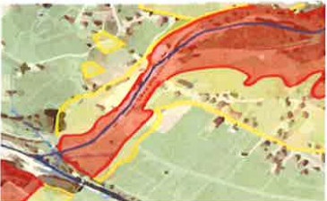
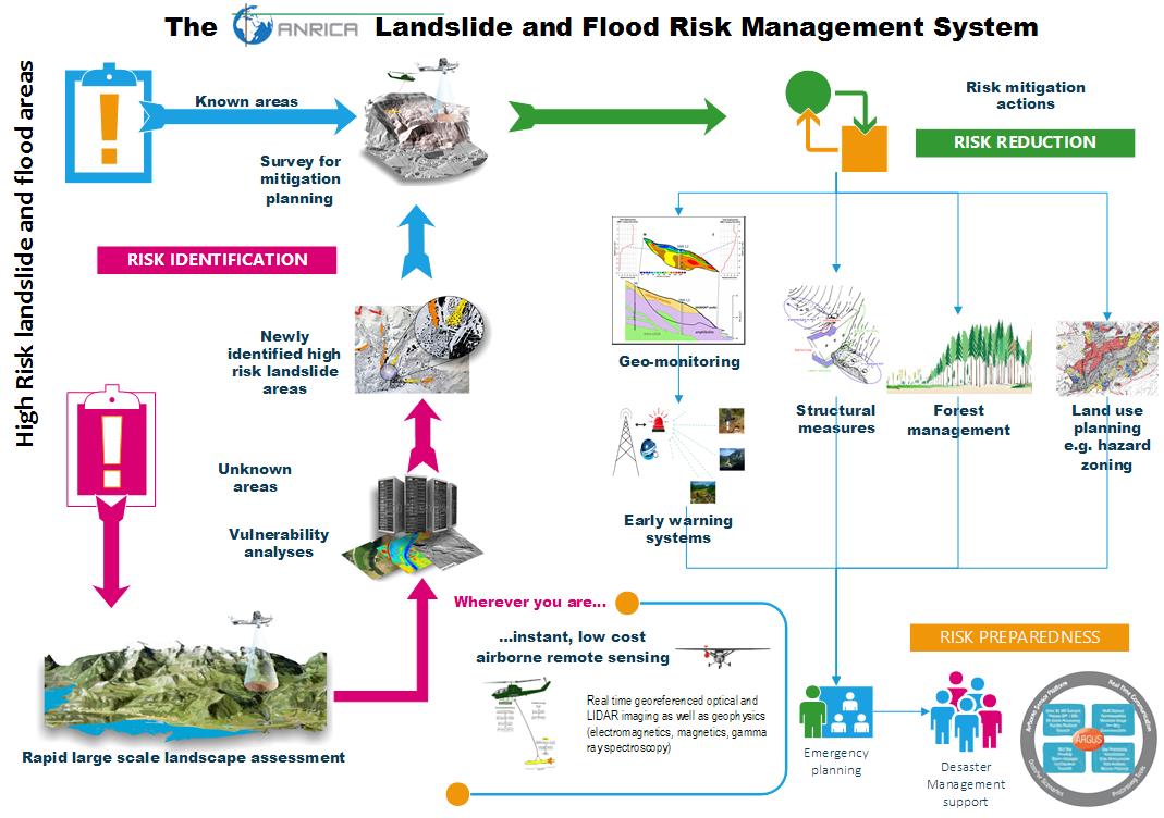
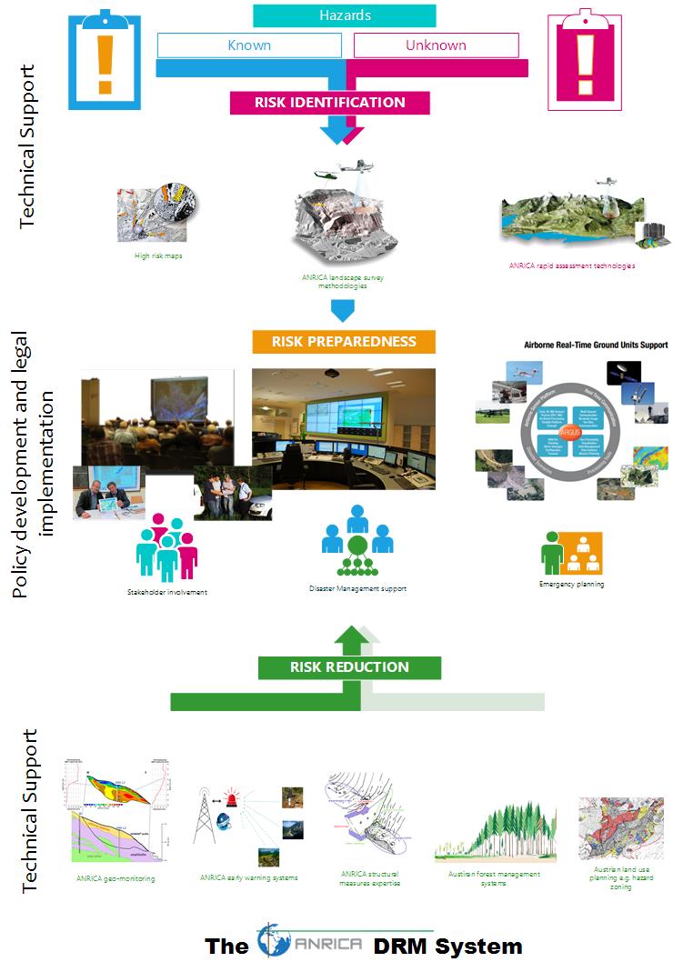
ANRICA combines geological surveys and rapid large-scale landscape assessments with early warning systems by geo-monitoring, forest management, structural measures and land use planning by hazard risk mapping to manage natural disaster crises.
Using a tried participatory communications approach, where communities and policy makers take part in finding solutions, a consortium of scientists, private sector and technological research experts work together through ANRICA to identify hazard areas, assess risk, and provide keen advice and action for risk management, reduction and mitigation.

The ANRICA DRM System
By identifying potential hazards, and introducing early warning systems and planning, reducing vulnerability to natural and man-made hazards such as flooding or landslides, we help policy-makers and authorities to save both livelihoods and lives.
As an alpine land, as well as a country with heavy reliance on hydro-electric power, Austrian know-how benefits from decades of experience in flood control and protection of the landscape from the threat of floods and landslides.
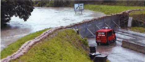
As climate-related challenges intensify, technology transfers among countries will be a key step in supporting the global drive for climate resilience. A well forecast consequence of a warming planet is the increasing intensity of rainstorms. This increase will cause more flooding, landslides, debris flows and rockfalls, resulting in untold damage to communities across the world.
Beyond climate-change related rainfall, a number of other scena-rios cause landslides, such as vulnerable or aging mining waste, electricity-generation dams, and flood contention barriers, greatly affecting valuable ecosystem services. Widespread erosion, the displacement of millions from their homes, the destruction of farming, mining, fishing and forestry livehoods, among so many others, imply tremendous financial losses to countries and tax payers.
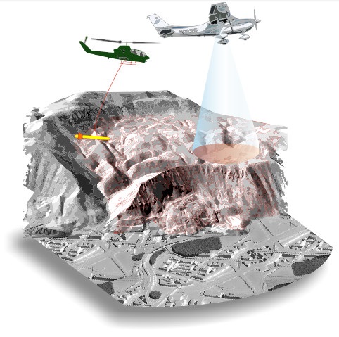
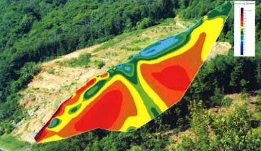
Tackling these issues requires strong technological solutions. ANRICA’s scientists and specialists combine skills from across the spectrum of Austria’s scientific, technical, and policy communities in order to evaluate local environmental capacity to sustain extreme weather events or geological instability; mapping expected ecosystem services and building projections based on soil and landscape properties, geological stability, historic and current rainfall patterns, and human activities. Assessing these historical patterns in targeted areas, this evaluation extends to estimates of ecosystem resilience and adaptive capacity.
More than technical evaluations and projections, ANRICA can design site and case-specific mitigation and remediation plans, ensuring participation from communities and governments in decision making, and advising stakeholders on mixed or exclusive strategies. In addition, harnessing Austria’s experience in environmental management, ANRICA can advise and design client-specific guidelines and protocols, essential in disaster management.
In the state of Styria, one of Austria’s nine provinces, alpine region prone to landslides due to geological conditions, state legislature passed a ‚Disaster Protection Act.’ This important piece of legislation requires a detailed – and annually updated – civil protection and emergency plan from all towns and counties. To assist in this process, Styria’s Civil Protection Department created an online planning system.
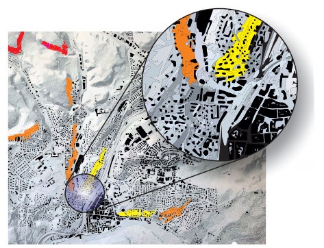
Using data available on landslides and rockfall in China, ANRICA partners AIT and Joanneum Research adapted sophisticated Austrian natural hazard prevention know-how in hazard modelling to produce comprehensive hazard mapping for some of that country’s riskiest landscapes in Gansu Province, near the town of Tianshui, a future infrastructure hub.
Ongoing cooperation between the two countries includes public policy and planning.
Austria’s experience implementing hazard maps in governmental spatial planning is particularly valuable to countries such as China, which are prone to geological hazards.
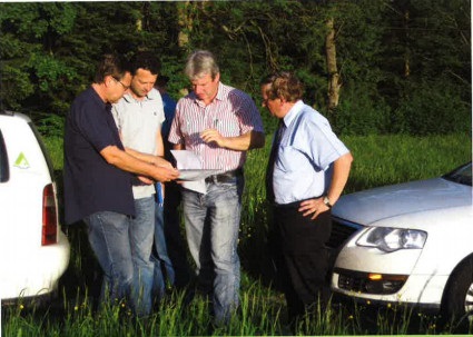
Chinese experts visited Austria, witnessing first-hand how hazard mapping is applied in a policy framework.
Austrian and Chinese experts will continue to work in Gansu Pro-vince with strong involvement of the Chinese provincial government.
ANRICA support includes all aspects of risk management. On the technical side, risk identification and risk reduction require advanced technological and scientific expertise. No less important, risk preparedness – addressed by policy and legislation – may be instrumental in risk prevention and in case of actual disasters.
A combination of methodologies contributes towards full risk identification, planning, avoidance and mitigation.
Using tried and tested principles of ‘integrated disaster management’, analysis of the civil protection laws of the region or country. Advice on and help in elaboration of measures related to civil protection, including public consultation and communication, establishment of comunity councils, warning centres, and all measures related to civil protection.
Projects such as EVIVA (air-assisted monitoring and analysis System for events and for protection in crisis situations with video-based behaviour analysis), ensures security technology for management of events with large crowds. Technology as developed in EVIVA allows for the first time comprehensive observation of the movement behaviour of people and early detection of critical situations (congestion, excessive people densities and incipient panic behavior, among others).
ABOUT US
ANRICA was founded back in 2009 by governmental and semi-governmental agencies and by private enterprises to join forces in international cooperation on climate change and rural development and is supported by the Austrian Federal Ministry of Agriculture, Forestry, Environment and Water Management.
CONTACT US
Austrian Natural Resources Management and International Cooperation Agency
Karlsgasse 9/2
A-1040 Vienna, Austria
Tel.: +43 1 914 60 00
Fax: +43 1 914 60 00 67
ZVR-827300462
© 2021 - ANRICA | Contact us | Credits | Data protection declaration